#10: More Mapping Bing(e)s

Following on from last week’s tip on Ordnance Survey mapping, it’s worth exploring a couple of other related topics. Reader Steven Grier recommends Walkhighlands: Scotland walks for invigorating walks north of the border (and not just the Highlands … it also covers Stevie’s native Burns country, so you could find some routes to get outdoors while practicing the forthcoming address).

Another regular, Mike Garrish, suggested looking at SysMaps, which aggregates a variety of different mapping services including Bing Maps. The UI takes a bit of getting used to but it does an effective job and makes up for Bing’s inexplicable removal of being able to export routes to .GPX files, by supporting that feature too.

Bing Maps can trace its lineage back nearly twenty years. Launched back in the days when Microsoft felt it needed to do everything its competitors were doing, even if not quite as well, the service was originally called Microsoft Virtual Earth (or Virtual North America, as one former colleague called it, given that everywhere outside of NA was still TBC; a bit like any sports tournament that has “World Series” in front of it). The Virtual Earth platform was aimed at developers looking to harness mapping in their sites and, later, apps. It offered up sometimes very good quality licensed mapping data and images for free, as part of the “Live” branding and then eventually morphed into being part of Bing. The Bing Maps Enterprise and Azure Maps services now form part of Microsoft’s “Map Platform”.

Start me up

The consumer-facing mapping service clings on despite having no discrete mobile client (in a browser, just go bingmaps.com to jump to it, or the alternative googlemaps.com, should you prefer being asked every five minutes if you’re rather use Chrome). There are mapping components in the expanding Microsoft Start mobile app, which is subsuming various formerly-separate apps like News and Money into a single application. Many of these things were at one point “MSN something”, might later have been lumped under Bing, but are now presented within Start like widgets, unsurprisingly slinging some ubiquitous Copilot in as well.

There’s a Copilot key coming to your next PC, the first major change since the Windows Key arrived with Windows 95, designed to make it easy to bring up the new Start menu. Remember that ‘Stones song? Here’s what it could have been like


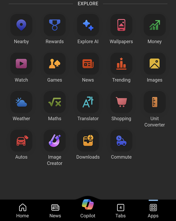
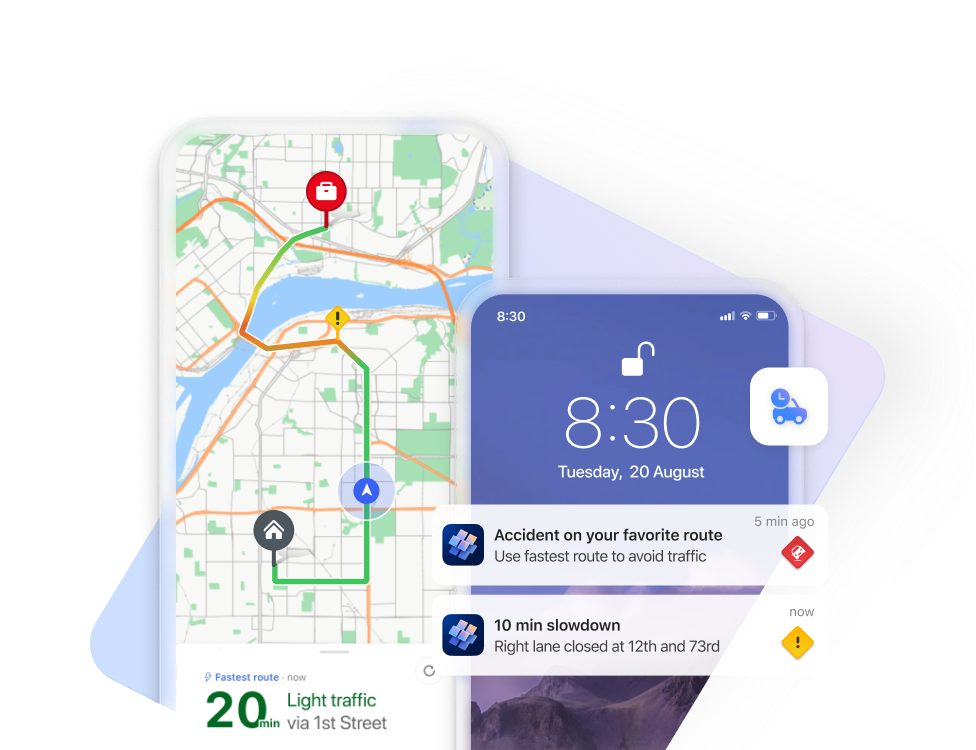
“News” gives you much the same feed as the default New Tab Page on the Edge browser (ie. news from customizable sources, peppered with ridiculous clickbait and stupid adverts… albeit seemingly less so in this instance). From a mapping perspective, there’s a “Nearby” tile which tells you what attractions are close to you, and a “Commute” function which will warn you on the phone when there is trouble on the road ahead.

image

The PC app, Maps, is having its wings clipped somewhat, no longer able to work using offline copies of maps. Place your bets on how much life there is in the Maps app, given that it’s likely no longer going to be installed by default.

While it is still available, there are some pretty neat things in that app, like adding Ink annotations to maps which are saved on your PC (though not synced across machines) and using a pen to measure distance on-screen. Notably cool and unique to the Maps app (as compared to Bing Maps in a browser) is the 3D Cities feature. This lists quite a number of major and minor cities in the US, though its international coverage is a bit patchy – the only UK city on offer is Southampton, and while Australia has a few, you’ll not be looking out over the Harbour Bridge.
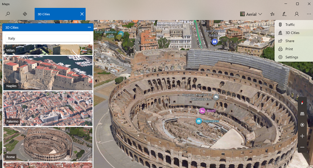
Back to the Streets

The Maps app offers no Ordnance Survey support for UK users but otherwise it basically does what Bing does in your browser.

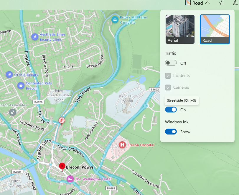
It is worth noting, though, that the “not nearly as good as Google Street View” service called Streetside has been expanding internationally where it was a bit of a desert when launched first in the US (see earlier “World Series” comment) – in partnership with Tom Tom, Streetside has been adding more coverage though sometimes there’s not much they can do about being unable to go places.

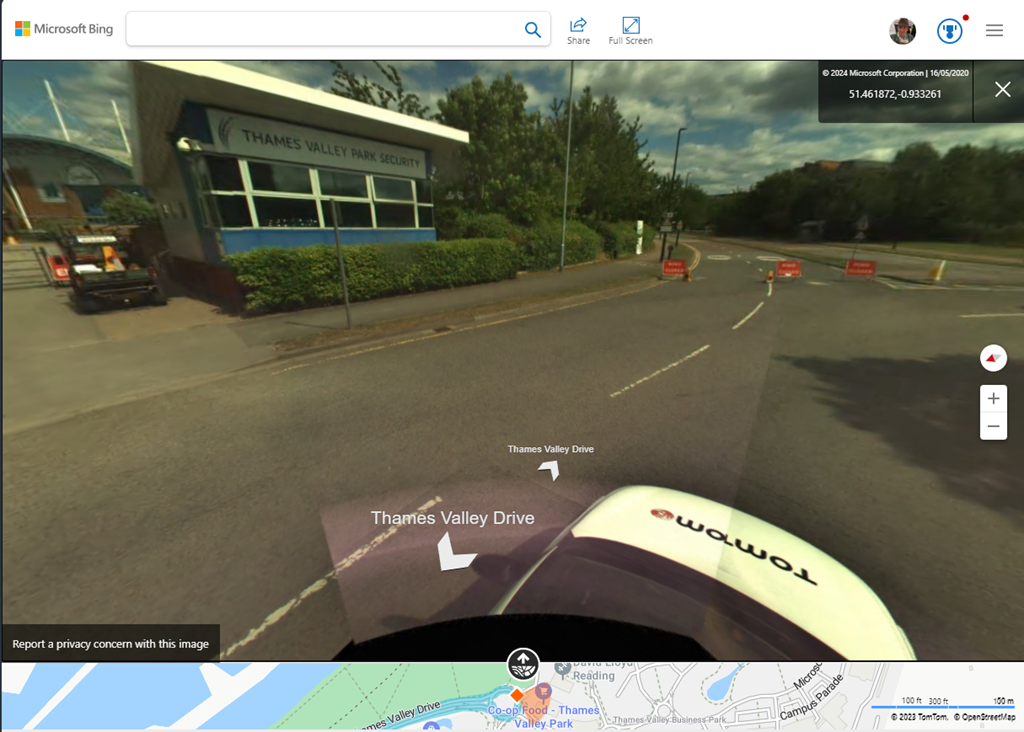
It’s worth checking out Streetside either in the Windows Maps app or just in Bing Maps on a browser; you’ll definitely get a different view from the one you’ll see in Google.

#9: Go for a walk

Hello, ToW readers! It’s been a few couple of months now since the recent yet erstwhile host of “Tip of the Week” was acquired and their new owner has thus far not completed the repurposing of their content, and therefore not given me confidence in writing any more for them, for now. In the meantime, I’ll continue to dribble this stuff onto LinkedIn each Friday (as Tip o’ the Week always was, in the days when it was a Microsoft internal email), following from the restarted numbering system as at the time it changed from Tip o’ to Tip of.

I do hope you enjoy. Yay.

Now that we’re finally in the grip of the New Year, some NY resolutions might have been sacrificed already; eating less, moving more, not drinking too much and the like. If you’re still keen, maybe each weekend, why not get out into the great beyond and go for a walk?

Step 1 will be to decide where you’re going to walk to. Technology provides lots of help in that regard – from local website guides offering “10 great winter walks to take in your area” type articles (typically stuffed with clickbait and stupid advertising, though), to mobile apps and web sites like MapMyWalk, AllTrails and Visorando. Community enthusiasts might post their favourite routes on these and other fora, possibly with reviews to tell you how muddy they are / how many angry bulls you might encounter etc.

Screenshot 2024-01-12 134756If you like the good old method of staring at a map and making up your own way, there are all the usual mapping tools available too. Google Maps clearly has a market share leadership position, and offers handy offline capabilities and walking directions, which sometimes include off-road footpaths as well. Not bad if you’re mostly in a built-up area, but once you’re in the sticks, you might be better off with more tailored alternatives. If you’re walking in London, check out Footways – a site showing a curated set of suggested “quiet” routes from A to B.

Apple pushes their alternative mapping software for Fruity device users, however if you follow a link to an Apple Maps location – eg https://maps.apple.com/?q=47.641944,-122.127222&t=k – and you’re not on an Apple device, it will send you to Google Maps instead. DuckDuckGo lets you view the map using another browser – eg https://duckduckgo.com/?q=47.641944%2C-122.127222&iaxm=maps – in case you feel like you’re missing out. [You’re not, btw]

If you’re planning a walk in the UK countryside, you’d do well to look at Ordnance Survey, a government funded department which publishes maps at varying scale and with key attributes highlighted. The organization dates back to the 18th century, set up to accurately map England in order to counter military incursions from troublesome neighbours. They still produce not-insignificantly-priced paper maps, however pinch-to-zoom is somewhat problematic on such offline media, so a mobile subscription based app with route planning, offline guidance and the like might be more fitting (and they have a 30% offer on annual subscriptions right now).

If you’re not inclined to subscribe, there is one alternative that’s useful when planning walks, even if you need to print the map out (or screen grab it to save the image to your phone): use Bing Maps.

Screenshot 2024-01-12 144611It’s easy to forget about Bing Maps (jump to bingmaps.com in a browser to get there quickly) since there’s no workable mobile solution, so most people will rely on the other main platforms. If you’re in the UK, however (and you set United Kingdom as your region in the hamburger menu on the top right) then you’ll be able to access Ordnance Survey mapping for free.

Look at the “Style” icon near the top right and you can choose road maps, satellite view and more, including Ordnance Survey. If you don’t see that option, you will need to play some more with your location settings. Zoom in or out until you get the right level, and you’ll see Explorer (slightly more detailed) and Landranger map views, showing key attractions with public footpaths marked.

Screenshot 2024-01-12 144928

Screenshot 2024-01-12 150614It’s brilliant. Right-click the map to use the measuring tool to draw your walk and calculate the distance. Screen-grab (WindowsKey+S) the section you want, and you could highlight your route from within the Snipping Tool before printing it out, nice and big and easy to read.


638 – Tracking and Mapping

clip_image001[6]
Looking back over the smartphone era of the last 15 or so years, one of the most transformative technologies is the confluence of mapping and geo-location, providing route guidance, finding things and even people. How did we manage to make our way around cities before maps in the palm of our hands? Just exit a tube or subway station anywhere in the world, and observe the herds of people spinning around looking at their phone trying to get a GPS fix.

Although Microsoft ceded the mobile phone space around 5 years ago, effectively leaving Android and iOS as the only options, the Bing Maps service still survives, even if fewer websites and mobile apps make use of it today. clip_image003[4]Windows 11 comes with a built-in Maps app which offers some decent functionality (and offline use), but lacks some of the features of Bing Maps in a browser, like the Ordnance Survey view showing public footpaths and other attractions in the UK (if you have the country setting to United Kingdom, that is).

Given the lack of “Bing Maps mobile” – and the commensurate lack of usage – the data that sits alongside may be less accurate, too; look at the reviews on the Windows Maps app in the store, and the main complaints are from people who don’t want it at all or comments about the map and PoI data being stale.

clip_image005[4]Some neat features in Bing Maps make it stand out from others – the Bird’s Eye view is cool, though not always as fresh or widely available as it used to be.

The team still updates imagery for the web view, provides data to the awesome 3D Cities feature in Windows Maps and contributes to the amazing scenery in Flight Simulator (even if some modders are switching Flight Sim to using Google Maps instead).

Bing Maps in a browser does sometimes offer a City Flyover option, which is akin to the Flight Sim view.

clip_image007[4]clip_image009[4]Bing’s Streetside can be sparse compared to Google’s Street View, even though the Google Maps car is sometimes thwarted with a “None Shall Pass” situation. Search the web and there are many – some NSFW – weird attractions found on Street View.

Some odd things can be found on Streetside too.

Apple used Google Maps data for its own maps app on the iPhone at first, but replaced with its own service which was at first poorly received. 10 years later, Apple Maps – available, of course, only to fruity device users – does a much better job and purports to be less cavalier with the user’s data than the advertising company. Despite a much larger number of users flocking to the universally available Google Maps, Apple Maps provides a good service for iOS users, and is there by default.

clip_image011[4]If you choose to surrender the use of your personal data to the advertising industry, Google Maps does offer some very useful capabilities in recording where you’ve been; it will remind you where you parked your car and let you see if you’ve visited a particular place before, and when.

clip_image013[4]If your family and friends consent, you can also share your whereabouts in real time, showing a pin in the map where they are, and when the location was last recorded.

This could be handy for checking if your kids are where they’re supposed to be, for friends arranging to meet or just knowing when to expect someone to come home. You can enable sharing of your location to each specified contact for a limited time or until it’s turned off, and it will also let you see their name, picture and other info including (!) battery level of their phone.

clip_image015[4]Sign into Google Maps on your computer, and you’ll be able to keep track of people a little more easily, too (as well as manage your own location sharing), and review your own timeline of where you’ve been. It’s usually somewhat fascinating and sometimes a little creepy.

Fortunately, you can choose to edit or remove certain items of data, export it to other formats or disable the collection of it altogether.

You give up some control of personal data, and you get some benefit from it.

As some say, them’s the breaks.

521 – Earth mapping

The last couple of decades have seen a revolution in user apps which offer location awareness and guidance. clip_image002 Automotive sat-navs were available some years ago, dating back to Honda’s electro Gyro-cator (now that’s a name) in 1986. CD and HDD based satnavs in cars became available over the years since, but typically were many thousands of dollars/pounds/etc as an option.

clip_image004Google Earth was first launched in 2001 as a desktop app, and Google Maps followed in the browser, a few years later. Microsoft launched “Virtual Earth” shortly after that, though it was initially more like “Virtual North America” as its global coverage was very lacking. Over time, Bing Maps launched a bunch of innovative services, like Birds Eye, which used licensed 3rd party images from spotter planes to stitch together a “45 degree” view rather than the typical straight-overhead aerial view.

clip_image006The source data for Birds Eye is a little out of date in some areas – though is still being updated in, er, North America (eg. see here and here), and maybe in other areas over time too. Point Birds Eye at Microsoft’s UK campus, and it shows Building 5 under construction, so the images are at least 8 years old, though since they no dates other than “© 2020”, there’s no obvious way to tell.

Google’s Street View shows the dates of images if there are multiple – click the down arrow next to “Street View” in the top left to view the history.

Meanwhile, as well as rowing back some of the nagging to get Edge browser users to move to Chrome, Google released Google Earth in the browser – it’s maybe not quite so smooth as the desktop app, but it’s quick to use – https://earth.google.com/web/ … see Microsoft UK’s TVP campus, here.

The Washington Post reports that Google changes the view of maps depending on the country the user is in, removing disputed borders and the likes – so it’s a complicated world. According to that same article, Bing Maps is a very minor player in map usage, with Apple Maps (after an inauspicious start) has grown to be the second-most-used mapping platform, due to mobile usage, either on the Maps app directly or via other 3rd party apps which use location-awareness from the mobile device.

clip_image008Bing Maps is used in many online services and other apps, however – like Microsoft’s forthcoming reboot of Flight Simulator, which supposedly features every airport in the world and uses data from Bing Maps, real-time weather reports and rendering in Azure, to provide a realistic flying view. There are some amazing videos on the Flight Simulator channel.

Tip o’ the Week 405 – Bye Bye, Bird’s Eye

clip_image001The Bird’s Eye view is/was one of the nicest bits in Bing Maps (get there quickly, at www.bingmaps.com – did you know you can type simply bingmaps in the address bar of Edge or Chrome, and press CTRL-ENTER to add the www and .com bits?).

clip_image003The Eagle-eyed amongst you may have spotted that some changes have happened… clicking on the drop-down control to change the map type no longer shows Birds Eye – instead, if you right-click on a point on the map, you clip_image005may get the option of viewing in bird’s eye view, and maybe streetside (though don’t expect the same level of coverage of Google Street View, at least if you’re outside the US).

If the bird’s eye option is greyed out, that means the view is not available – or no longer available, as out of date maps have been temporarily removed from the platform. Or at least removed from being easily found – if the missing area is on a boundary between data sets that are being updated, it may be possible to find a nearby place, and scroll across to find the view you’d originally searched for.

clip_image007Shortly after going live, UK users found a temporary problem – clicking on the bird’s eye view (when it’s not greyed out) didn’t do anything if your locale was “United Kingdom”.

If selecting the view doesn’t work for you, try clicking on the “hamburger” menu in the top right, and change the country setting to be United States… whereupon the bird’s eye will work, but the Ordnance Survey view will disappear.

So for a while, it looks like Brits needed to say Bye Bye, to the Bird’s Eye (for your morning coffee, see what that last link will mean for Western civilisation). Boom Boom.

clip_image009Of course, another aerial view option would be to turn to Google Maps – one tip for using the aerial view (activate via the Satellite icon in the lower left), is that if you see older images, you may well be looking at a map layer associated with the 3D view, where the service renders the view by clip_image011“underlaying” building shapes with the images. Handy in a city, maybe, less so in the countryside.

In some cases, more recent images are available if you switch 3D off, by going to the hamburger menu in the top left; try disabling 3D to see what difference that makes to your aerial view.

Tip o’ the Week 390 – Paint it black

SHOCK, HORROR!”, the internet & news media said, “Microsoft is killing Paint!”. Cue the opportunityclip_image002 to make Clippy comparisons, and reflect on a bit of software that appeared in its first version in Windows 1.0, bring out the odd eccentric who manages to produce quite amazing art using Paint (like Pat Hines, who’s tried other paint software but “never managed to ‘connect’ with it”, or Jim’ll Paint It, who paints odd scenes on request, and whose fondness for MSPaint means he prefers the WinXP version).

Most of us probably don’t use MSPaint for much these days; maybe the odd bit of clumsy touching-up of images, or using it to snip bits out of screen grabs for documentation purposes.

Here’s one use case, if you’re in the UK and want to print out a map for a walk you’re going to do – fire up MSPAINT, set the clip_image004canvas dimensions to something huge like 4096×4096 (in File / Properties), then go to Bing Maps and screen grab (WindowsKey+S, or use the Snipping Tool) the relevant sections of your planned walking route, looking at the Ordnance Survey view in the top right, and zooming in so you see the footpath details.

For longish walks, you’ll struggle to fit the whole route on one screen at the max detail level, so you’ll need to grab a bit, paste it onto the Paint canvas, move the map view, grab the next section, then using Paint, assemble the bits together like overlaying jigsaw pieces by moving your newest-pasted chunk around so it fits the rest. Copy the whole finished lot into a Word doc, and print.

Anyway, Paint is most definitely not dead – it’s just going to be an app that’s packaged and maybe delivered via the Windows Store, just like lots of other apps that are traditionally part of Windows and may or may not be installed by default (like Calc, Mail, Groove etc). There’s always Paint3D, too (ToW 358).

If you do need to do some more intensive image manipulation, especially of photos, there are many free options, from Adobe’s PhotoShop Express or the built-in Microsoft Photos app, which lets you carry out simple tweaks to photos you’ve acquired. For more creating and pixel-by-pixel tweaking of images, though, you’d be hard pressed to find a better value yet powerful tool than Paint.NET. It looks a bit 1990s in some respects, but it’s a simple and effective image editing tool, that has been likened to the bits of Photoshop that people like, simplified and delivered for free.

Find out more about Paint.NET here – download directly from here, and keep an eye out for a packaged version of Paint.NET hitting the Windows Store at some point, too. Who knows – maybe it will be there before MSPaint is loaded on the cart and taken away?

Tip o’ the Week 383 – Windows Maps refresh

clip_image001Can you remember the time when, if you wanted to know how to get somewhere, you needed to look on a paper map? Before mapping was at all available online, people would either buy paper maps or license software packages – sometimes at great expense – that had road information in a database, so they could plan journeys.

A company called NextBase released an early PC application called “Autoroute” that was bought by fleet transport managers and the likes, who might have saved time and fuel by more efficiently clip_image002planning the routes that their vehicles would take. This made it worth the £500 or so that the software package cost†.

Microsoft went on to acquire NextBase and released AutoRoute in some markets, and Streets & Trips in others, and went on to sell it for the more modest £99‡.

this figure is made up, because I can’t for the life of me find any reference to the actual cost, but I do remember it was A LOT. Like, enough to drive a lot of pirate copies…
so is this figure

Now AutoRoute, Streets & Trips and their more professional data analysis counterpart, MapPoint, have all shuffled off to make way for the more popular – and mostly free – online mapping tools that people use today. Microsoft acquired MultiMap along the way, to bring additional expertise and technology to the Bing Maps platform.

So, most people will now use Bing Maps or Google Maps (Street View not available in all places) for finding directions. The latter is particularly good for finding places where you don’t need to know their address; put the name of a restaurant into Google Maps in a browser, or onto the Google Maps app on your phone, and you can get directions straight there without even bothering to look it up first.

Tip: if you search for the name of a place in Bing Maps, it shows you the result in a pop-out pane on the left, but sometimes leaves you trying to zoom & scroll, zoom & scroll to get the detail around your destination… to quickly go there, click once on the title banner (“Microsoft UK” in the example below) to collapse it, and once again to bring it back – at which point, the map view should zoom to the point.

clip_image003

Anyway, Bing Maps is improving its ability to find stuff around any given point – nearby restaurants, attractions, parking, that kind of thing – and this has now percolated through into a nicely updated Maps application for Windows 10 and Windows 10 Mobile.

To see what version of Windows Maps you’re running, click the elipsis in the top right, choose Settings and scroll to the bottom to see the version number – at time of writing, the updated version is Maps 5.1705.1391.0 but insiders will be on a later release.

clip_image004

If you search for a place, or even just right-click somewhere on a map to Drop a Pin, you’ll get the option to see what’s nearby and quickly find more details, plan a route to the destination etc.

As well as integrating place info better, the Maps app also has some nice traffic reporting capabilities – if Cortana knows your home and work locations, Maps will immediately think about your commute when you click on the traffic lights icon near the top right. As well as showing a colour coded clip_image005traffic map, it shows public traffic cameras and lets you easily access them.

And if you plan a route using the driving directions, you can pin that route to your Start menu if it’s one you use a lot…

clip_image006

Read more about other updates to Windows Maps in the recent weeks.

Tip o’ the Week 318 – Read Maps on Windows 10

clip_image001The development of accurate maps was one of humankind’s biggest advances (after learning to talk) that enabled exploration and other developments. Mobile and online technology have advanced mapping (especially timely access to accurate maps) in ways that only a few years ago, most of us could never have imagined.

Automated maps in cars have been around for quite a while but it was only the widespread availability of GPS and the falling cost of electronics that made it feasible to think of sat nav as standard kit for lots of cars, though it doesn’t stop some gouging car makers from charging a healthy premium for installing a system that is years-old in design and will be completely obsolete by the time the user gets their next smartphone.

Most of us can remember the first time we saw Google Earth – spent a while looking up where we live, where we used to live, where we’ve been on holiday etc. Amazingly, though, Google didn’t know what they were going to do with the technology when they acquired it, but figured if they build it and people start using it, they’ll figure out how to monetise that later. And they did.

clip_image002

Bing Maps

Microsoft has its own mapping technologies, of course – sometimes developed in partnership or licensed from 3rd parties, and there are a couple of places where they stand out from those available elsewhere: the Birds Eye view in Bing Maps shows some cracking imagery, for example.

clip_image003

If you’re set to use Bing Maps in the UK (go to the gear icon on the top right, click Settings, Region and choose United Kingdom) then you’ll also get access to the Ordnance Survey* maps which show topographical features, footpaths, bridleways, landmarks and all sorts – see above map of part of an old bit of West Berks as an example.

Windows 10 PC & Mobile

clip_image004Windows 8.x had a Maps app that was interesting to a degree, but didn’t really offer much more than you’d get in a browser (apart from offline support). HERE Maps still publishes a decent app for PC users, though it’s still not a lot more than you’d get if you just went to a mapping site like Bing, or HERE.com itself. The new HERE site doesn’t even promote the Windows app, so make of that what you will.

clip_image005clip_image007There is a new Maps app for Windows 10 mobile & PC, that is quite a bit better, though. The app lets you download maps locally and will also function as a sat nav if you have a GPS in your device – so either a Windows 10 Mobile device (aka a phone) or some sort of tablet thing could be used in-car, with turn-by-turn directions, 3D views etc.  

There are essentially 3 cool features about the maps app that set it apart from others, especially when used on a phone with Windows 10 Mobile:

  • Traffic and Cameras – by turning on the traffic or cameras options, you’ll see what the state of the roads are, and if you tap on the camera icons shown, you’ll see a recent – but sadly not date or time-stamped – image of the scene
  • clip_image008StreetSide view – if you’re in the area covered by the subset of the world where a scene has been recorded by the StreetSide camera wagon, then you’ll see imagery on your device
  • Car favourites – don’t recreate Dude, Where’s My Car? – you can add a Favourite (press the hamburger icon on the top left, choose Favourites, and you’ll see a clip_image009list of favourite places, including Home, Work and, now, Car). You set the current location of  your car and optionally add a photo from the camera, so if you want to record the zone/row location sign in the airport, or the situ and registration number of the potential door-swinger parked next to you so you might have some proof when they ding your car…

* The Ordnance Survey is one of the oldest mapping organisations in the world, tracing its history back to the aftermath of some troublesome northerners planning to install an itinerant French waif as their king.

[Billy Connolly – ergo, seriously, NSFWhas a few words to say about BPC]